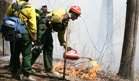
Prescribed Burning on the Wayne National Forest
The USDA Forest Service’s Wayne National Forest, Athens Ranger District is planning to conduct prescribed burning operations within the next few weeks. Depending on weather conditions, the district anticipates conditions may be favorable for prescribed burning operations anytime during the period of March 1 through May 1.
Historically, Native Americans used repeated burning on the landscape to create open oak-hickory forests that were beneficial for wildlife they hunted and foods they gathered. The Wayne National Forest seeks to keep oak-hickory forests from losing dominance on the landscape in southeast Ohio. This forest type is fire dependent, meaning occasional prescribed burning actually helps them out-compete other species of trees like shade loving maple and beech. Through the use of prescribed burning, the Forest Service is creating conditions that allow young oak and hickory trees to thrive. A forest with oak and hickory trees provide critical habitat to various wildlife species.
Significant preparations are undertaken prior to the Wayne National Forest conducting prescribed burns, including physical visits to neighboring communities and homes to provide awareness of the project and explain what residents might expect. Fire lines have been constructed in order to provide the highest degree of safety. Burn units are surrounded by existing roads, trails, and constructed fire breaks that aid in the control of the burn.
The Wayne National Forest follows strict guidelines for conducting prescribed burns, and uses environmental factors including temperature, humidity, atmosphere stability, wind-direction and speed as well as smoke disbursement. If any of these conditions are not within limits, the burns will be postponed.
For more information, visit the Wayne National Forest website. Follow the Wayne National Forest on Twitter: @waynenationalfs and Facebook.
Burn Window: Approximately March 1 through May 1, 2017
Utah Ridge Middle Bailey Prescribed Burn
Size: Approximately 470 acres
Location: Athens County, Dover and York Townships, in the vicinity of Coal Run Road and West Bailey Road.
Gore Greendale Prescribed Burn
Size: Approximately 145 acres
Location: Hocking County, Falls Gore and Green Townships, in the vicinity of Arnold Road and Gore Greendale Road.
The U.S. Forest Service is an agency of the U.S. Department of Agriculture, a mission of sustaining the health, diversity and productivity of the nation’s forests and grasslands to meet the needs of present and future generations. The Forest Service’s Eastern Region includes twenty states in the Midwest and East, stretching from Maine, to Maryland, to Missouri, to Minnesota. There are 17 national forests and one national tallgrass prairie in the Eastern Region.
The U.S. Forest Service manages 193 million acres of public land, provides assistance to state and private landowners, and maintains the largest forestry research organization in the world. Public lands the Forest Service manages contribute more than $13 billion to the economy each year through visitor spending alone. Those same lands provide 20 percent of the nation’s clean water supply, a value estimated at $7.2 billion per year. The agency has either a direct or indirect role in stewardship of about 80 percent of the 850 million forested acres within the U.S., of which 100 million acres are urban forests where most Americans live.


Comments